Field Communication Software that Puts You on the Map.
Drop geotagged pins, run site inspections, and generate construction field reports on any job site. Powered by real-time map geolocation and precise site positioning.
Leaders choosing SiteMarker


Field management software built for on-site professionals
Choose your industry:
SiteMarker empowers site professionals to address site issues through geotagged data and integrated CAD/GIS workflows. Purpose-built for SWPPP inspections, punchlist tracking, and construction field reporting. Automating reports reduces delays, ensures compliance, and keeps projects on schedule.
More for Civil EngineeringBring your project site online with mobile, geolocated data collection and reporting
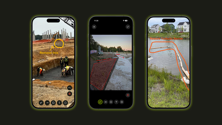
Locate yourself on-site
Overlay site plans
Drop geotagged pins with site data
Generate field reports in minutes
Lightning Fast Inspections
Save time, reduce costs and minimize risk
See your exact position on the plan
Drop pins at your exact location using GPS-powered site positioning. Pair with Bluetooth GPS units for survey-grade precision.
Load any drawing as a live map overlay
Load PDFs, images, and KMZ files as CAD and GIS overlays to align geolocation with your construction documents.
Tag and track issues as you walk the site
Custom categories and tags for inspections, punchlist items, and SWPPP tracking, keeping field and office in sync.
Generate a report in seconds, not hours
Streamline construction field reporting by converting geotagged pins into construction daily reports with a few taps.
Build a record that holds up automatically
Map layers, pins, photos, and reports are backed up with multi-layer secure storage for defensible construction documentation.
Stay connected in the office
Create and manage project data with a streamlined workflow
Upload CAD Layers
Upload linework, CAD files, and construction documents as overlays on the project map.
Align Georeferenced Overlays
Auto-align new georeferenced overlays based on the position and scale of previous uploads for quick project setup.
Generate Field Reports
View geotagged pins dropped on-site within the map. Roll them into automated field reports with just a few clicks.
Stakeholder Sharing
Distribute field reports to stakeholders inside and outside your organization with a single share link.
What our customers are saying
From the largest firms in the US to growing regional groups, hear how SiteMarker is transforming the way teams document, report, and collaborate on-site.
How well do you really want to do what you do? How well do you want to look to your clients? SiteMarker is going to give you that opportunity exponentially better.
Donald J.
Construction Adm. Project Manager
SeamonWhiteside
We use SiteMarker to rapidly develop multifamily residential projects. It saves us time and money while increasing the quality of our end product.
Cameron P.
Senior Project Manager
Development Resource Group
It used to take me 3 hours to make a report…with SiteMarker it's ready before I leave the site.
Earl B.
Construction Manager
Lennar
If you took SiteMarker away and asked our team to go back to paper, most of them would probably quit.
Jason Q.
Senior Construction Manager
BJWSA