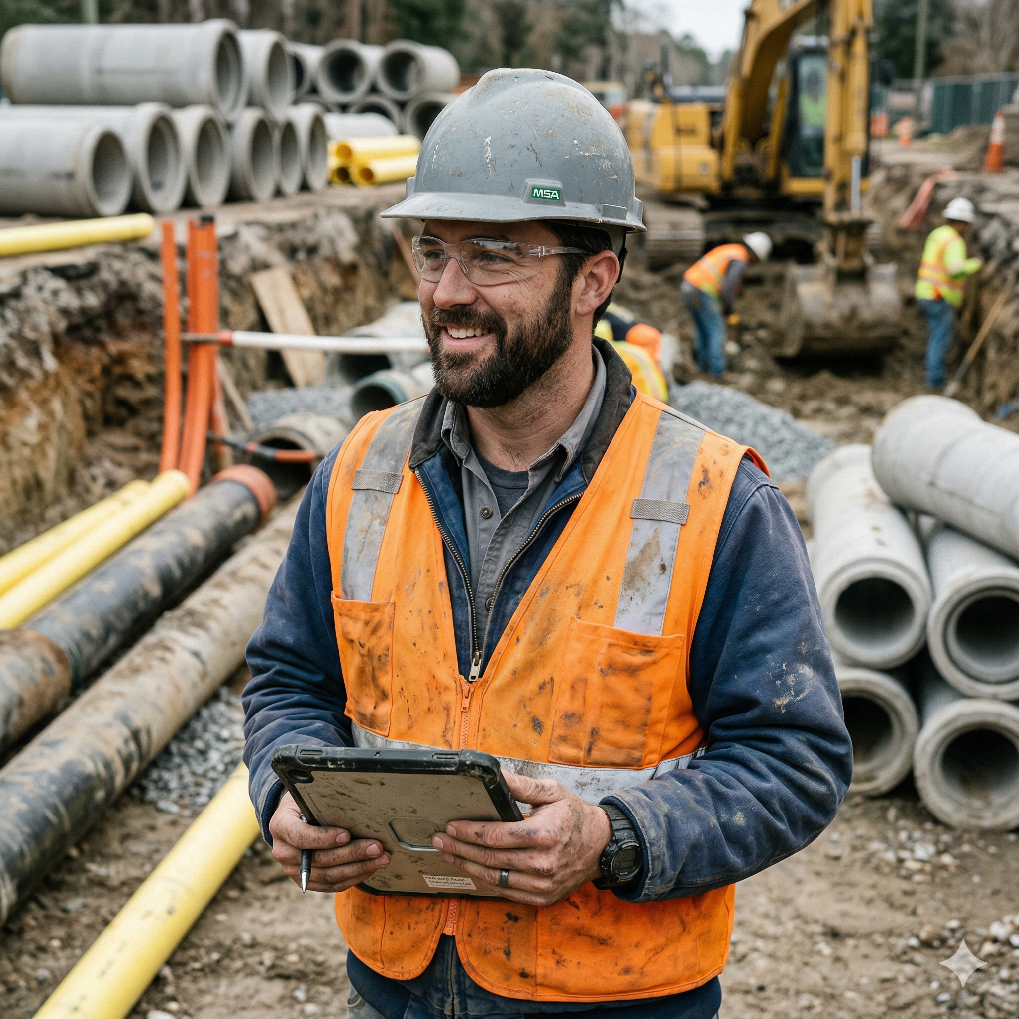
The site visit is only half the job. We handle the other half.
Civil engineers spend hours every week reconstructing site visits from memory. SiteMarker documents everything on-site, so you leave with a complete, defensible record.
Over 3,000 projects managed daily by firms across the country


Use Cases
Where Civil Engineers use SiteMarker
SWPPP Inspections
Document BMPs, erosion controls, and discharge points with geo-referenced pins and photos. Generate inspection reports on-site before you leave: compliant, timestamped, and ready to submit.
Punch Lists
Walk the site and build your punch list in real time. Every deficiency is pinned to its exact location on the plan, assigned to the responsible party, and tracked to close-out. No clipboard, no back-office data entry.
Survey Verifications
Overlay your control drawings on a live map and document field conditions against them as you walk. Flag discrepancies with photos and notes tied to precise coordinates, before they turn into rework.
Pre-Survey Data Collection
Capture existing conditions, utility conflicts, and site constraints directly on your plan before fieldwork begins. SiteMarker pins export to AutoCAD, so everything you collect feeds straight into your survey workflow.
Your current reality
Every site visit creates two jobs: the one you do on-site, and the one waiting for you back at the desk.
At the Site
Observing conditions, taking pictures of the issues, taking written and mental notes. Your clipboard and camera roll are filling up fast.
On your Way Back
Mentally replaying what you saw, hoping the photos are enough to reconstruct the story accurately.
At your Desk
Rebuilding the site visit from memory. Matching photos to locations. Formatting reports.
You've rebuilt enough site visits from memory. With SiteMarker, the report is a by-product of the site visit. Not something extra you have to do.
What rebuilding the site visit from memory actually costs you.
What you observed on-site is only useful if it makes it into the report accurately. Most of the time, something gets lost on the way.
$1,712
lost per project to reporting overhead and rework. It compounds across every engagement you run.
50%
of site visit time spent on documentation that should have been done in the field, not back at your desk.
$337k
per year in recoverable value left on the table. Firms running SiteMarker across their projects are already capturing it.
of all field data is structured, accessible, and usable.
McKinsey & Company, The Next Normal in Construction - the other 96% is lost in photos, texts, and paper.
Source: SiteMarker ROI Case Study with SeamonWhiteside+, conducted 2024. Data averaged across 212 active projects. McKinsey & Company, The Next Normal in Construction (2020).
Construction field documentation, reimagined
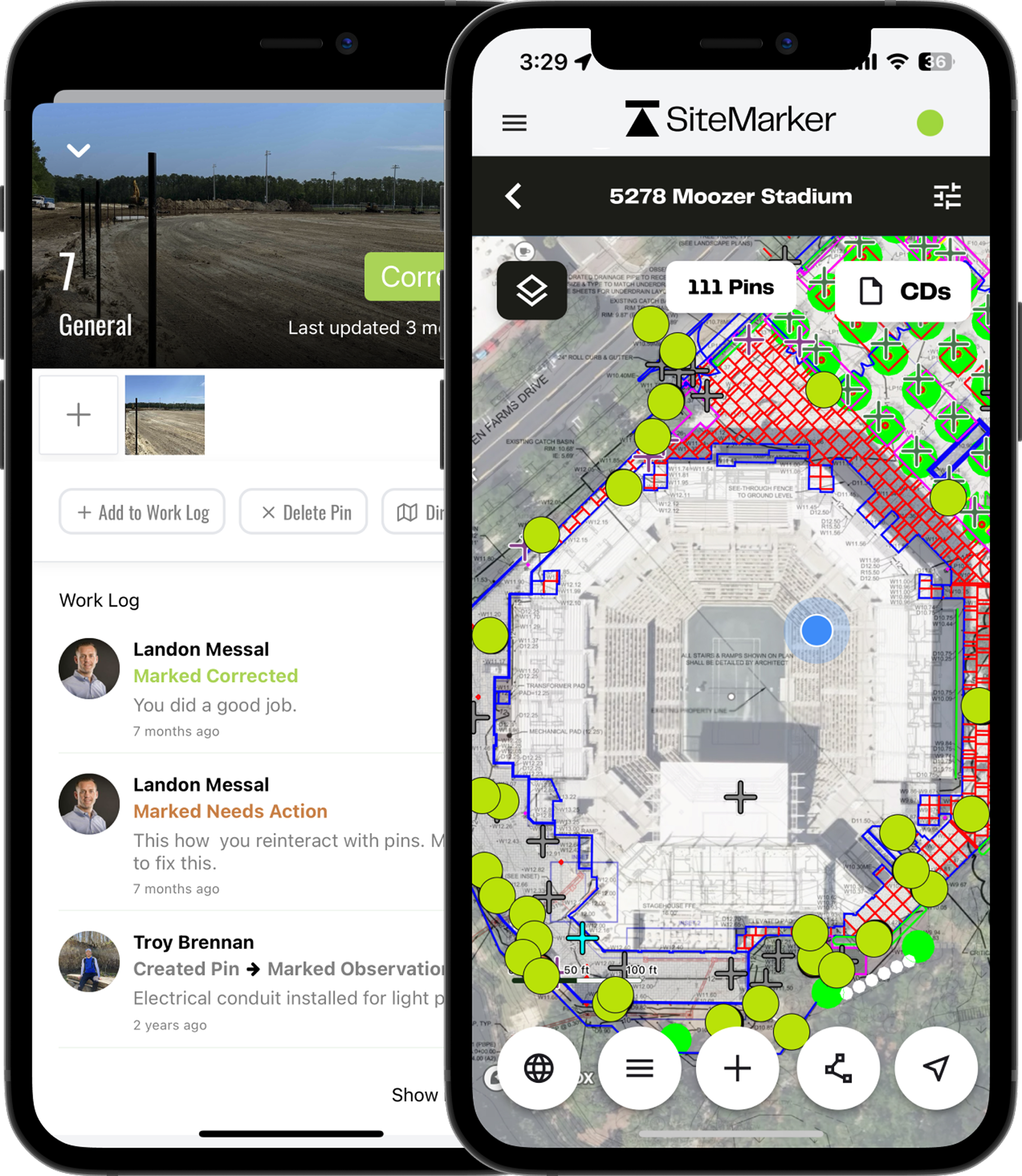
Everything documented. Before you leave the site.
From the moment you arrive on-site, SiteMarker is building your report. Pin observations, attach photos, and assign issues as you walk, so by the time you reach your truck, you're done.
Locate
Walk the site with your drawings already loaded. Every observation lands exactly where it belongs. No GPS guesswork, no matching photos to locations later.
Document
Drop a pin, add a photo, write a note. All tied to a precise location. You're building the report as you walk, not recreating it hours later.
Report
Done before you leave the gate. Select your pins and the report generates in seconds, formatted, geo-referenced, and ready to send. No desk time, no Word template.
Take Action
Issues assigned and tracked the moment they're found. No lost texts, no missed emails, no question about who was supposed to handle what.
Built for Engineers
Every tool you need between the site visit and the final report.
Precise Geolocation
Drop pins at your exact location on-site. Pair with GNSS receivers for sub-meter accuracy on grading, stormwater, and utility projects.
CAD & GIS Layer Overlays
Upload PDFs, KMZ files, and georeferenced images as map layers. Align construction documents with real-world coordinates so every pin lands exactly where it should.
One-Tap Report Generation
Select pins from any project map and generate formatted, client-ready reports in seconds, complete with photos, notes, location data, and timestamps.
Custom Pin Tags & Categories
Organize observations with custom categories and tags. Filter by deficiency type, phase, or trade to keep field data structured and actionable.
Real-Time Stakeholder Sharing
Share live project maps and reports with anyone, no login required for viewers. Keep clients, contractors, and regulatory agencies in the loop.
Secure File Storage
Map layers, pins, photos, and reports are all backed up with multi-layer secured storage. Maintain a defensible record for every project.
“If you took SiteMarker away and asked our team to go back to paper, most of them would probably quit.”
Jason Q.
Senior Construction Manager
BJWSA
Request a Tailored Demo0
Projects Managed Daily
0
Site Visit Time Saved
0
Reports Generated
0
Client Satisfaction
† SiteMarker platform data, averaged across 3,000+ active projects.
Common Questions
Everything civil engineers want to know about SiteMarker.
How do civil engineers typically handle site inspections and field documentation?+
The standard workflow, photos to a camera roll, handwritten notes, and a report typed up back at the office, is slow and leaves room for error. Details get lost between the field and the desk. SiteMarker lets engineers build the inspection record on-site, pinning observations directly to a live plan, so the report is done before they leave the property.
Can SiteMarker overlay CAD and GIS plans in the field?+
Yes. Upload PDFs, KMZ files, and georeferenced images as live map underlays. Walk the site with your construction documents loaded and document observations against them in real time, so every pin lands exactly where it should.
How does SiteMarker help reduce construction rework?+
SiteMarker ties every field observation to a precise GPS location. Issues are documented once, correctly, and visible to the right people immediately, cutting the miscommunications that send teams back to the same site over and over.
If a contractor disputes a finding or a client questions a site condition, what documentation do I have to back it up?+
Every pin in SiteMarker is GPS-located, timestamped, and tied to the engineer who created it. Photos, notes, and observations are all structured and geo-referenced, not scattered across a camera roll. When a dispute comes up, you're not reconstructing what you think you saw. You have a verifiable, time-stamped field record that shows exactly what was found, where, and when.
How does this differ from fillable forms, like I use in goCanvas?+
goCanvas and similar tools digitize a paper form. You're still filling out fields one by one, detached from any spatial context. SiteMarker works differently: every observation is pinned directly to a map or drawing, so location is captured automatically as part of the workflow, not entered as a text field. The report isn't assembled from form submissions. It's generated from geo-referenced pins, photos, and notes you placed while walking the site. The result is a document that shows not just what you found, but exactly where on the plan you found it, which is what clients, contractors, and regulators actually need.
What our customers are saying.
From the largest firms in the US to growing regional groups, hear how SiteMarker is transforming the way teams document, report, and collaborate on-site.
How well do you really want to do what you do? How well do you want to look to your clients? SiteMarker is going to give you that opportunity exponentially better.
Donald J.
Construction Adm. Project Manager
SeamonWhiteside
We use SiteMarker to rapidly develop multifamily residential projects, it saves us time and money while increasing the quality of our end product.
Cameron P.
Senior Project Manager
Development Resource Group
It used to take me 3 hours to make a report…with SiteMarker it's ready before I leave the site.
Earl B.
Construction Manager
Lennar
If you took SiteMarker away and asked our team to go back to paper, most of them would probably quit.
Jason Q.
Senior Construction Manager
BJWSA